Hidden Worlds and Where to find them: The importance of upland heath and bog
“After gazing at the sky for some time, I came to the conclusion that such beauty had been reserved for remote and dangerous places, and that nature has good reasons for demanding special sacrifices from those who dare to contemplate it.”
— Richard E Byrd, Alone (1938)
I am currently in year two of my 2.5-year diploma in Botanical Illustration with the Society of Botanical Artists, as a botanist and ecologist it is always been something I’ve wanted to do, plus a chance to revive my plant ecology work at the same time. I am aiming to try and complete the course illustrating only native and naturalised wild plants (with an exception being the fruit and vegetable assignments), as they are my interest and I’ve always been taught to paint what you love. I will be completing the course in coloured pencil, now accepted as an equal in the art medium world; I love the array of colours and choice you get in pencils and nothing cheers me up more than my steadily growing pencil collection. I also wanted to combine my interest in fastpacking/trail running with the course, using my time outdoors to get inspiration for the assignments I submit. One of my long-term challenges is to solo fastpack the Cape Wrath Trail, a 230-mile (370 km) epic from Fort William to the northernmost point of mainland Scotland, Cape Wrath. It is wild and remote, requiring a series of committed weekends to cover sections cut off from roads and transport. It’s my plan once I’ve finished my diploma to fastpack the sections which will allow me to cover more miles than traditional walking it and also more time to explore the botany and record it via drawing and painting. Ideally, I’d love to get some funding to do a really good job of illustrating what’s on the trail to then put into an exhibition, but that will be a wait-and-see next year. Aside from the remote, mountainous terrain the trail also works it way through some of my favourite landscapes, a hidden world of Mires and Heath micro-habitats many of which are internationally important for the bird life they support as well as functioning as a major carbon store, whilst helping to sequester atmospheric carbon and lock it in slow growing layers of peat, the key species being Sphagnum mosses. These are plant communities that are often forgotten and deemed to be uninteresting but botanically they are a fascinating mosaic and one that I’d like to help more people appreciate; what follows is a breakdown of the main plant communities along the trail and also a small discussion on their importance and management.
Wet Oceanic Heaths of the North West Highlands

Below images from L to R: Bog Asphodel, Tormentil, Crossed-leaved heather and Heath rush (with Common blue damselfly).

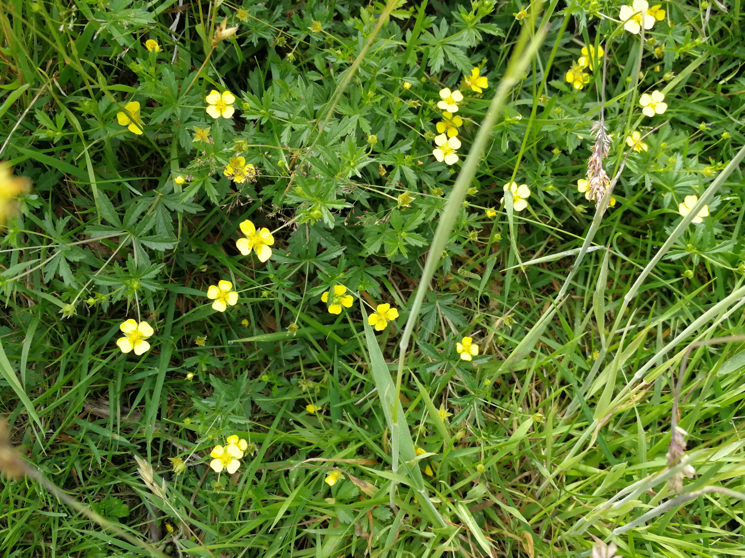


The vast ochre-brown landscapes that covers the expanse of North-West Scotland belong to a plant community of the sedge Trichophorum cespitosum (Deer grass) and a mix of the dwarf shrubs Erica tetralix (Cross-leaved heather) and Calluna vulgaris (Bell heather) intermixed with the uplands grasses of Molinia caerulea (Purple Moor grass), Potentilla erecta (Tormentil) and dotted with Narthecium ossifragnum (Bog asphodel) and Eriophorum angustifolium (Cottongrass), on a microlevel depending on microtopography, hydrology and chemistry this is accompanied by species such as the sedges Carex spp. and rush Juncus squarrosus (Heath rush), the insectavoire Drosera rotundifolia (Round-leaved sundew), Sphagnum species and the moss Dampylopus atroviens, small plants of Myrica Gale (Bog Myrtle, used in natural midge repellents) and Schoenus nigricans (Black bog rush). In the most northerly reaches on north facing aspects, it shelters the internationally important ‘northern hepatic mat’ a complex community of rare liverworts confined to oceanic regions and with few international parallels
Below images L to R: typical north facing habitat of the heptatic mat, closer image illustrating moss and liverwort cushion, Herbertus aduncus ssp. hutchinsiae (Juniper Prongwort), Adelanthus lindenbergianus (Lindenberg’s Featherwort) and Herbertus borealis (Northern Prongwort)


This landscape is an important example of a non-natural community that is of international conservation importance, due to its limited existence elsewhere in the world. A landscape formed through ancient neolithic deforestation and waterlogging, following a change from a postglacial cold-dry to wet ocean-driven climate. It presents an outstanding habitat for upland birds especially Buzzard (Buteo buteo), Raven (Orvus carax), short-eared owls (Asio flammaeus), and the Golden Eagle (Aquila chrysaetos); in the northern parts it forms and important breeding ground for Greenshank (Tringa nebuleria).
This is one community that does benefit from light grazing and also ‘conservation burning’ a practice of superficial burning every 10-15 years to remove the woody rank heather, and make way for fresh growth. However this should be done by conservation practitioners who understand the ecology and local environment so avoiding the damper stands, wind clipped or rocky areas that harbour areas of liverworts.
Blanket Mire Mesoscapes
Of significant international importance is the other great landscape of North and North West Scotland, the pale ochre-gold T. ceaspitosum and E.vaginatium (Common Cottongrass) blanket mire. We use the term mire for a mesotope landscape that is dominated by the plant community, but within it shows microhabitat variations in blanket bog communities. In his report, Lindsay et al. (1988) estimated that 13% of the Blanket Bog in the world is in Great Britain and Ireland, which is even more impressive given that as islands we only constitute 0.23% of the land area in the world. Within the broader mesotope landscape micro variations allow for a gradient of Spahgnum species, spiked with N. Ossifragum, sticky Drosera spps, Potentilla erecta and Dactylohiza maculata. On the flatter plateaus this broad community is mixed with the Mire bog pool communities, in fact it is estimated that in the Northern reaches of this community upto 50% may be open water.
The botanical communities support a myriad of invertebrates, which intern are food to upland birds including internationally important populations of the waders Greenshank, Dunlin (Calidris Alpina) and Golden Plover (Pluvialis apricpria). The Mires most northerly extent on Shetland and Orkney is home to Whinbrels, Great and Arctic Skaus, Red throated divers and Red necked Phalaropes. Many of these sites are designated as RAMSAR sites and form RSPB Nature reserves such as the Forsinard reserve in the Caithness Flow Country.
Peat Matters
Globally, these mire are incredibly important for carbon sequestration, especially those that retain their diverse peat-building sphagnum communities, this also makes them major carbon sources as peat depths can extend to 10m below the surface. The Peat mass when healthy is hydrophilic and contains a permanently wet lower layer and a seasonally dry upper layer which is typically only about 10 cm deep, what keeps the peat mass healthy is the surface vegetation layer on top (I like to think of it as the sun tan lotion that stops you from burning). Once this surface layer is removed it exposes the seasonally wet/dry upper layer, this is not an issue during wet seasons as it will remain hydrophilic but once in the dry season, the peat starts to desiccate becoming hydrophobic and easily erodible, which is what occurs once the rain comes back and starts to wash it away. Over time the gradual removal of exposed dry bare peat leads to linear gullies which are a feature in the South Pennines but more problematic is that the bare peat alters the hydrological balance in the surrounding ‘intact’ peatland leading to the drying out of vegetation on the edges. This vegetation which is now largely woody in mass becomes a fire hazard, resulting in moorland fires that are very difficult to control and stop, we believe that the worst areas of erosion seen in the Pennines as on Kinder Scout and Bleaklow have been caused by historic wildfires (pre-dating WW2 B&W aerial photography) resulting in extensive areas of bare peat fringed with low diversity areas of vegetation around the fringes.
As there is no historical photography that shows what these areas looked like pre-erosion, it wasn’t until as a post-doc I started to look at aerial photography from across the Scottish highlands focusing on flat plateau areas of similar topography to the Pennies, I noticed subtle similarities. In these mostly intact blanket mires on the plateaus you find mire pool patterns with a mix of permanent and seasonal bog pools, they are magical places to be, however, in some areas you find through trampling (of deer) and burning that the vegetation bridge that has separated the smaller pools has now disintegrated, exposing the peat underneath that has subsequently started to erode allowing the smaller pools to coalesce into a bigger one. As this has repeatedly happened during extended dry periods the pools have become dried out creating permanent peat hollows, the fringing wet sphagnum communities are replaced with drier communities leading to a landscape that is prone to damage by fire and a starting point for the blanket erosion previously discussed.
It is therefore essential that these intact peatland systems are managed correctly, it is not that they are being burnt on purpose but that they fall victim to poor management of controlled burns lower down where the land is managed for driven grouse shooting. Once these sensitive wet communities are damaged they can’t recover quickly enough to stop the underlying peat being eroded. In my time working on peatlands I have quickly come to the conclusion that it is impossible to guarantee full control of burning as the wind direction and speed can change quickly; and that the potential accidental damage done to sensitive plant communities can be catastrophic and often irreversible, leading to mass peat erosion and the release of atmospheric and particulate carbon, that it would be safer to just stop burning and respect this land for what it is.
References
Lindsay et al., (1998) The Flow Country: The Peatlands of Caithness and Sutherland. Nature Conservancy Council, Peterborough